


There is a strip of pavement that winds through Seattle like a vein through a living body. It threads past waterfront breweries and beneath canopies of bigleaf maple. It hugs the shoreline of Lake Washington and slices through the University of Washington campus, where students in headphones nearly collide with Lycra-clad cyclists every single morning. It passes through some of the most expensive real estate in the Pacific Northwest and some of the most contentious urban planning battles in American history. It is, by almost every measure, the most important 20 miles of non-motorized infrastructure in Washington State.
The Burke-Gilman Trail is not simply a path. It is a transportation artery, a community gathering space, an economic engine, a political lightning rod, and — for the nearly half a million people who use it annually — one of the defining features of what makes Seattle feel like Seattle.
But long before anyone laced up a pair of running shoes or strapped on a helmet to ride it, this corridor carried something else entirely: freight trains, timber, and the raw ambitions of two men who bet everything on a city that barely existed.
The Railroad That Started It All
The story of the Burke-Gilman Trail begins in 1885, a full century before anyone thought to pave it. That year, a Seattle judge named Thomas Burke and a businessman named Daniel Gilman gathered ten investors and set out to do something audacious: build a railroad that would put their small, rain-soaked city on the national map.
Their company, the Seattle, Lake Shore and Eastern Railway, was designed to connect Seattle northward to the Canadian border at Sumas and eastward toward the Cascade foothills. The route they carved out followed the north shore of the Lake Washington Ship Canal, hugged the lakeshore, and punched through the forests of what are now the residential neighborhoods of northeast Seattle. In its best years, the railroad was a vital commercial lifeline, hauling timber from Puget Sound logging camps and carrying passengers between growing communities.
Burke and Gilman’s railroad never quite reached its most ambitious destination. It got as far as Arlington to the north and Rattlesnake Prairie to the east, but the effort still mattered enormously. It demonstrated that Seattle was more than a frontier outpost — it was a city with infrastructure, industry, and investors willing to put capital behind its future.
The Northern Pacific Railway absorbed the line around 1890. It changed corporate hands again when Burlington Northern was formed in 1970. And then, just one year later, Burlington Northern applied to abandon the corridor altogether.
By 1971, the trains had essentially stopped running. Rail traffic had dwindled to almost nothing. The once-critical corridor was becoming an afterthought, overgrown with blackberry bushes and littered with rusting track. The railroad wanted to sell the land off to private developers and be done with it.
That might have been the end of the story. In most American cities, it would have been.
But this was Seattle in the early 1970s, and something was stirring.
The Citizen Revolt That Built a Trail
What happened next is one of the great grassroots conservation stories in the history of American urban planning, and it started — of all places — in a quiet residential neighborhood called Matthews Beach.
In 1968, a group of neighbors who lived near the abandoned rail corridor noticed something. They used the old railroad overpass to cross busy Sand Point Way on walks with their families. The overgrown right-of-way, despite its neglect, was already functioning as an informal footpath. Kids played along the tracks. Dog walkers followed the old rail bed through the trees. The corridor had a kind of natural gravity — people were drawn to it.
When word got out that Burlington Northern planned to sell the land to private buyers, these neighbors organized. They formed the Burke-Gilman Trail Park Committee, naming it after the two railroad founders whose names kept appearing in old property deeds and historical records. The committee was led by people like Merrill Hille and Lucile Estell, ordinary residents who became tireless advocates for what was then a radical idea: turning abandoned train tracks into a public walking and cycling trail.
This was the early 1970s. The rail-trail concept barely existed in the United States. Wisconsin’s Elroy-Sparta State Trail had opened in 1967, but it was located in a rural area, far from the complexities of an urban environment. What the Burke-Gilman advocates proposed was different. They wanted to thread a non-motorized trail through the dense fabric of an established city, past homes and businesses, alongside a major university, and through neighborhoods where residents were far from unanimous about the idea.
Opposition was fierce. Homeowners along the corridor worried about crime, property values, and privacy. Some business owners objected. Burlington Northern wanted its money from the land sale. The Interstate Commerce Commission initially sided with the railroad.
But the community pushed back. On September 12, 1973, more than 2,000 people participated in a hike-in along the old rail line, converging on Matthews Beach Park in a rally that turned heads at city hall. Over 1,600 signatures were collected on a petition asking Burlington Northern to donate the land for public use. Environmental groups — the Sierra Club, the Izaak Walton League, the League of American Wheelmen — threw their weight behind the effort.
Seattle Mayor Wes Uhlman became a critical ally. He fought for the trail with a stubbornness that bordered on obsession, later saying he felt the rail corridor represented a once-in-a-lifetime opportunity. In February 1973, Burlington Northern finally agreed to exchange the railroad land for other industrial property, and the city, King County, and the University of Washington cooperated to develop the route.
On August 19, 1978, the first 12.1 miles of the Burke-Gilman Trail — running from Gas Works Park on the shore of Lake Union northeast to Tracy Owen Station in Kenmore — were officially dedicated. Runners and joggers set off from Gas Works Park. Cyclists rode from Kenmore. Both groups met at Matthews Beach, where Seattle Mayor Charles Royer and King County Executive John Spellman addressed the crowd.
The Burke-Gilman Trail was open. And nothing about how Seattle moved would ever be the same.
What the Trail Looks Like Today
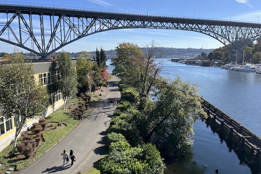
Nearly five decades after that first dedication, the Burke-Gilman Trail has grown into a 20-mile paved corridor stretching from Golden Gardens Park on Puget Sound in the Ballard neighborhood all the way to Blyth Park in Bothell, where it connects with the Sammamish River Trail. Together, these routes form a continuous cycling and walking network that extends more than 40 miles into the eastern suburbs of King County.
The trail passes through an astonishing range of urban landscapes. Starting at the western end, it runs along the Shilshole Bay waterfront and past the Hiram Chittenden Locks, where the waters of the Lake Washington Ship Canal meet Puget Sound. The route winds through the Fremont neighborhood — Seattle’s self-proclaimed “Center of the Universe” — where it crosses near funky shops, craft breweries, and the famous Fremont Troll sculpture lurking under the Aurora Bridge.
From Fremont, the trail follows the ship canal past Gas Works Park, one of Seattle’s most iconic green spaces, with its decommissioned gasification plant rising against the skyline like an industrial relic from another century. This stretch offers some of the best views of downtown Seattle and the Space Needle.
The route then passes through the University of Washington campus, threading alongside the massive Husky Stadium and within easy reach of the university’s Link light rail station. It is here that the trail is at its busiest — a teeming corridor of commuting students, faculty on lunch-hour jogs, and touring cyclists navigating the chaos with varying degrees of confidence.
East of the university, the character of the trail shifts. It passes through the quieter residential neighborhoods of Hawthorne Hills, Windermere, and Sand Point, where the tree cover thickens and the noise of the city fades. Magnuson Park, a sprawling 350-acre green space on the shore of Lake Washington, offers a major rest stop and recreational hub. Matthews Beach Park — the very place where the trail movement was born — provides sandy lakefront access during summer months.
Continuing north, the trail runs alongside Lake Washington through Lake Forest Park, Kenmore, and into Bothell. The scenery here is lush and lakeside, with views of the water filtering through alder and Douglas fir. At its eastern terminus, the trail connects seamlessly with the Sammamish River Trail, which carries riders and walkers another 11 miles through wine country in Woodinville and beyond.
The entire route is nearly flat — a lasting gift of its railroad origins — with few significant intersection crossings. The surface is paved asphalt with a soft-surface shoulder, and the trail is accessible under ADA standards. It is jointly maintained by the Seattle Department of Transportation, Seattle Parks and Recreation, and King County.
The Missing Link — Seattle’s Longest Running Infrastructure Debate
No discussion of the Burke-Gilman Trail is complete without confronting its most persistent headache: the so-called Missing Link.
For decades, the trail has had a gap in the Ballard neighborhood, a stretch of roughly 1.4 miles between the Ballard Locks and 11th Avenue NW where the route passes through an industrial corridor along Shilshole Avenue NW. This gap forces cyclists and pedestrians onto busy industrial streets shared with trucks, freight trains from the Ballard Terminal Railroad, and heavy commercial traffic.
The Missing Link has been the subject of one of the longest-running infrastructure disputes in Seattle history. Since the 1990s, proposals to build a dedicated trail through this corridor have been met with fierce opposition from local business owners who raised legitimate concerns about safety and liability. The convergence of freight rail, truck traffic, and trail users on the narrow Shilshole waterfront created a genuine engineering and safety challenge, not just a political one.
Environmental review, design proposals, lawsuits, appeals, and counter-suits dragged on for decades. Multiple city administrations attempted to move the project forward, only to be blocked by legal challenges or community opposition. The debate became something of a civic punchline — a symbol of Seattle’s legendary difficulty in completing infrastructure projects.
As of 2026, the original Shilshole alignment remains unbuilt. But the city has finally shifted course. Following the passage of the Seattle Transportation Levy in November 2024, the Seattle City Council advanced an alternative route using NW Market Street, Leary Avenue NW, and 17th Avenue NW — a path that bypasses the industrial waterfront entirely. Whether this alternative will satisfy trail advocates who have waited decades for a proper connection remains to be seen, but it represents the most significant progress on the issue in a generation.
More Than Recreation — The Trail as a Transportation Revolution
It would be easy to think of the Burke-Gilman Trail as a recreational amenity — a nice place to jog on a Saturday morning. And it is that. But to reduce it to recreation alone is to miss the larger significance of what this trail has accomplished.
The Burke-Gilman is, first and foremost, a commuter corridor. Thousands of Seattle residents use it daily to get to work, to school, and to transit connections. The trail provides a direct, car-free route between some of the city’s most populated neighborhoods and its largest employer — the University of Washington — as well as connections to the Link light rail system and regional bus networks.
In a city where traffic congestion ranks among the worst in the nation, the Burke-Gilman Trail offers proof that when proper infrastructure is provided, large numbers of people will choose healthy, pollution-free, non-motorized transportation. This was the argument trail advocates made in the 1970s, and it has been validated by decades of data and daily ridership that continues to climb.
The trail also functions as an economic catalyst. Studies of rail-trail development across the country consistently show that properties near well-maintained trails increase in value. The neighborhoods along the Burke-Gilman — from the upscale homes of Windermere to the commercial districts of Fremont and the University District — benefit from the visibility, foot traffic, and quality-of-life improvements that the trail provides. Restaurants, breweries, and shops along the route draw customers directly from the trail’s user base.
And the Burke-Gilman’s influence has extended far beyond Seattle. As one of the first urban rail-trails in the United States, it served as a proof of concept for cities across the country. When Peter Harnik and other trail advocates in Washington, D.C., were searching for models of what was possible in the 1970s and 1980s, the Burke-Gilman was a beacon. Dozens of similar rail-trail conversions followed, and the concept has now become a mainstream tool of urban planning worldwide.
Practical Tips for Riding and Walking the Trail
For anyone planning to explore the Burke-Gilman Trail, a few practical considerations are worth noting.
The trail is open year-round and accessible at no cost. Parking is available at several points along the route, with the largest lots at Golden Gardens Park on the western end and Blyth Park in Bothell on the eastern end. Gas Works Park, Matthews Beach Park, Magnuson Park, and Log Boom Park in Kenmore all offer additional access points with parking, restrooms, and water fountains.
Trail etiquette matters on the Burke-Gilman. The path can get genuinely crowded, particularly on sunny weekends and during weekday commuting hours near the university. All users should keep to the right, and faster cyclists should announce their presence with an audible signal before passing. Dogs must be leashed with a maximum leash length of eight feet. Horses and motorized vehicles are prohibited.
Serious cyclists looking for speed should be aware that the trail’s busiest segments are not suitable for paceline riding or high-velocity training. The City of Seattle recommends that fast cyclists use alternative routes during congested periods, and the Seattle Bicycling Guide Map suggests several options.
The trail connects at its eastern terminus with the Sammamish River Trail, which extends 11 miles through Woodinville — making it possible to combine the two routes for a 30-plus-mile ride through some of the most scenic terrain in the Puget Sound region. At its western end, the trail links to the Elliott Bay Trail and the broader network of Seattle cycling routes.
Weather in Seattle being what it is, rain gear is advisable for much of the year. But the trail’s flat, paved surface handles wet conditions well, and some of the most atmospheric walks along the route happen on overcast days when the fog settles over Lake Washington and the city sounds are muffled by low clouds.
A Living Legacy
The Burke-Gilman Trail is, in many ways, a story about what happens when ordinary people refuse to let a good idea die. It was not built by some grand municipal vision or a top-down government initiative. It was built because a handful of neighbors in Matthews Beach looked at an abandoned rail line and saw something better than a row of condominiums. They organized, they rallied, they knocked on doors, they wrote letters, and they refused to give up even when the railroad, the federal government, and a sizable chunk of their own community told them it would never work.
Nearly half a century later, their creation has become one of the most heavily used non-motorized trails in the Pacific Northwest. It has reshaped how hundreds of thousands of people commute, exercise, socialize, and experience the city. It has inspired similar projects across the country and around the world. And it continues to evolve, with new connections, the eventual resolution of the Missing Link, and integration into an ever-expanding regional trail network that stretches from the Puget Sound shoreline to the foothills of the Cascades.
The old railroad that Thomas Burke and Daniel Gilman built in 1885 was meant to connect Seattle to the wider world. In a way neither man could have foreseen, it still does — just not with locomotives. It connects neighborhoods to each other, commuters to their workplaces, families to lakefront parks, and a rapidly growing city to the simple, elemental pleasure of moving under one’s own power through a landscape that, even after all these years, still has the capacity to take your breath away.
That is the Burke-Gilman Trail. And Seattle would not be Seattle without it.


