

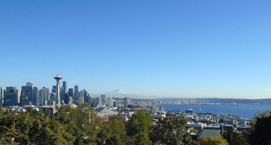
Seattle’s topography delivers what flat cities can only approximate through skyscrapers and observation decks—natural elevation that transforms ordinary parks into viewing platforms revealing the city’s relationship with water, mountains, and sky. The glaciers that carved Puget Sound left behind hills steep enough to challenge cyclists and reward pedestrians with perspectives that shift from industrial grit to alpine grandeur within a single panorama. These parks function as the city’s public living rooms, spaces where locals bring visitors to prove Seattle lives up to its postcard reputation and where longtime residents still stop to appreciate views that familiarity never quite renders ordinary.
Kerry Park’s Iconic Vantage and Its Complications
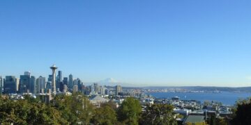
Kerry Park occupies barely half an acre on Queen Anne Hill’s southern slope, yet this tiny space produces more Seattle photographs than any location except perhaps Pike Place Market. The view encompasses downtown’s skyline with the Space Needle prominently centered, Elliott Bay spreading westward, and Mount Rainier floating above the horizon on clear days. Sunset transforms the scene into something magazine covers and tourism campaigns exploit relentlessly—the city glowing golden against darkening water while the mountain catches alpenglow that persists after the lowlands fall into shadow.
The park’s fame creates problems that undermine the experience it promises. Photographers arrive before dawn to claim positions for sunrise shoots. Tour buses disgorge passengers who spend three minutes snapping photos before reboarding. Weekends bring crowds that make contemplation impossible and turn the small park into a jostling mass of people competing for unobstructed sight lines. Neighborhood residents have grown weary of the traffic, parking chaos, and late-night visitors treating their streets as extensions of the park.
The best approach to Kerry Park involves timing and lowered expectations. Weekday mornings offer relative solitude, as do winter days when rain keeps casual visitors away and clouds obscure the mountain that draws crowds. The view remains extraordinary even when Rainier hides, though many tourists seem disappointed by its absence, as if the mountain’s visibility represents some moral obligation the city has failed to meet.
The park itself offers minimal amenities—a small lawn, a few benches, and a sculpture that most visitors barely notice while focused on the view. It functions purely as a viewing platform, not a destination for picnics or recreation. This single-purpose design makes sense given the space constraints, but it means staying longer than twenty minutes requires dedication to staring at scenery or tolerance for crowds that increase as the day progresses.
Gas Works Park’s Industrial Romanticism
Gas Works Park transforms industrial dereliction into public space with a view that emphasizes Seattle’s working waterfront heritage alongside its natural beauty. The park occupies the site of a former gasification plant on Lake Union’s north shore, retaining rusting machinery as sculptural elements that some find compellingly post-apocalyptic and others consider eyesores that should have been removed during remediation. The view extends across Lake Union to downtown, with the Space Needle rising above the skyline and seaplanes landing and taking off from the lake throughout the day.
The park’s great hill—actually a mound of dirt covering contaminated soil that couldn’t be removed economically—provides elevation for kite flying on windy days and sledding during Seattle’s occasional snowfalls. People sprawl on the grass during summer, spreading blankets for picnics while watching sailboats, kayakers, and rowing crews navigate the lake. The Fourth of July brings massive crowds for the best view of fireworks launched from barges on Lake Union, though getting to and from the park through traffic jams and pedestrian masses tests patience severely.
Gas Works demonstrates how industrial sites can be reclaimed for public use while acknowledging rather than erasing their histories. The preserved machinery serves as reminder that Seattle’s waterfront wasn’t always recreational space but rather working infrastructure supporting the city’s economy. This honest approach to history feels particularly Seattle—practical, slightly gritty, and resistant to the sanitized nostalgia that treats the past as theme park set design.
The park attracts diverse users. Runners and cyclists pass through on routes circling the lake. Families occupy the play area and open lawns. Photography students shoot the industrial structures against various light conditions. Homeless individuals sleep in corners during the day, creating occasional tensions with other park users but generally coexisting peacefully. The social mix reflects Seattle’s complicated relationship with public space—broadly accessible but marked by the inequalities and challenges the city struggles to address.
Discovery Park’s Wilderness Within the City
Discovery Park’s 534 acres make it Seattle’s largest park, offering miles of trails through forest, meadow, and bluff environments that feel genuinely wild despite sitting within city limits. The park occupies the former Fort Lawton military base on Magnolia Bluff, preserving a peninsula that extends into Puget Sound and provides views across the water to the Olympic Mountains, north to the San Juan Islands, and south toward the downtown skyline.
The West Point Lighthouse sits at the park’s northern tip, accessible via trails that descend from forested bluffs to beaches littered with driftwood and shells. The walk to the lighthouse takes thirty to forty minutes from the main parking area, creating enough separation from the city to foster genuine quiet punctuated only by waves, bird calls, and wind through trees. Seals occasionally rest on offshore rocks. Eagles nest in tall Douglas firs. The experience resembles visiting a wilderness area hours from Seattle rather than a park accessible via city bus.
Views from Discovery Park’s bluffs reveal shipping lanes busy with container ships, ferries, and pleasure boats moving between Puget Sound’s various ports and passages. Watching these vessels against mountain backdrops provides perspective on Seattle’s position as a maritime gateway connecting inland North America to Pacific trade routes. The view emphasizes process and movement rather than static scenery—ships appearing from behind points of land, crossing the horizon, and disappearing into distance.
The park’s size allows for actual hiking rather than just walking. Loop trails total several miles, climbing through forest before emerging onto meadow with views that change with seasons. Summer brings dry grass and wildflowers. Winter brings mud and bare branches but also clarity—the Olympics sharpen into distinct peaks visible in detail that summer haze obscures. Spring offers the Northwest’s signature palette of greens in gradations from chartreuse to deep forest tones.
Discovery Park attracts serious walkers, birders, and people seeking actual nature experience rather than manicured urban parkland. The meadows and forests require maintenance to prevent invasive species from overwhelming native plants, but the aesthetic prioritizes ecological function over ornamental beauty. Trails can be rough and muddy. Restrooms are basic. The park makes few concessions to casual visitors expecting groomed paths and convenient amenities.
Volunteer Park’s Central Reserve and Water Tower Views
Volunteer Park anchors Capitol Hill as the neighborhood’s central green space, combining formal gardens, a conservatory, a museum, and recreational lawns with a distinctive water tower offering 360-degree views from its observation platform. The park dates to the Olmsted Brothers’ early 20th-century vision for Seattle’s park system, embodying ideals about public space providing respite from urban density and opportunities for all residents to access nature and beauty regardless of economic means.
Climbing the water tower’s spiral staircase rewards the modest effort with views that contextualize Capitol Hill within the broader city. Lake Union spreads to the north with the Cascade Range rising beyond. Downtown towers rise to the south. The Space Needle marks Queen Anne to the west. The tower’s height reveals patterns invisible from ground level—how the street grid shifts orientation between neighborhoods, where density concentrates, how hills and valleys structure the city’s topography.
The observation platform attracts fewer visitors than Kerry Park despite comparable views, perhaps because it requires climbing stairs or because Volunteer Park’s inland position lacks the waterfront drama that photographs so compellingly. This relative obscurity makes it preferable for people seeking views without crowds. The platform accommodates perhaps a dozen people comfortably, and even on perfect summer weekends it rarely fills to capacity.
Volunteer Park itself offers attractions beyond the view. The Volunteer Park Conservatory houses tropical plants in a Victorian greenhouse that provides warmth and humidity welcome during Seattle’s gray winters. The Seattle Asian Art Museum occupies an art deco building at the park’s northern edge, its collections and architecture meriting visits independent of the park itself. Lawns accommodate sunbathers, picnickers, and games during good weather. The park serves Capitol Hill residents as their backyard, a place for regular use rather than special occasions.
The neighborhood surrounding Volunteer Park has gentrified dramatically over decades, transforming from middle-class residential to one of the city’s most expensive areas. Housing values reflect proximity to the park, demonstrating how public green space increases private real estate values—a dynamic that raises questions about who benefits from public investments and how parks affect neighborhood affordability.
Ella Bailey Park’s Secret Magnolia View
Ella Bailey Park remains relatively unknown despite occupying prime real estate on Magnolia Bluff with unobstructed views across Elliott Bay to downtown and the Olympics beyond. The small park features a narrow strip of lawn along the bluff edge, a few benches, and trails descending the steep slope toward the water. Its obscurity stems partly from limited parking and location on a residential street that doesn’t attract through traffic.
The view from Ella Bailey emphasizes Elliott Bay’s industrial character. Shipping terminals line the waterfront below. Container cranes load and unload cargo. Tugboats push barges. Ferries cross between Seattle and Bainbridge Island. The scene demonstrates that Seattle remains a working port despite the waterfront’s increasing conversion to recreational and residential uses. Trains rumble along tracks at the base of the bluff, their whistles echoing off the water.
Sunset transforms the industrial view into something approaching sublime. The Olympics turn purple silhouettes. The water reflects pink and orange. Downtown’s towers glow. The juxtaposition of industrial infrastructure and natural beauty creates an aesthetic particular to Seattle, where working landscapes and wilderness coexist in ways that confound attempts to separate nature from culture into distinct categories.
The park attracts neighborhood residents walking dogs, couples seeking romantic viewpoints, and occasional photographers pursuing angles less cliched than Kerry Park’s famous vista. The relative isolation makes it unsuitable for solo visits after dark—the park has no lighting and limited foot traffic that might deter problems. But during daylight hours it offers peaceful viewing that compensates for bare-bones amenities.
Rizal Park’s Commanding Beacon Hill Position
Rizal Park perches on Beacon Hill’s crest at one of Seattle’s highest elevations, providing sweeping views from the Olympics to the Cascades with downtown, Elliott Bay, and the industrial areas of Georgetown and South Park spread below. The park honors Filipino heritage, featuring a statue of José Rizal and design elements reflecting Filipino culture. It serves the neighborhood’s diverse population while offering views that rival or exceed better-known locations.
The elevation reveals Seattle’s topographical drama. The city’s hills become obvious from this vantage, their varying heights and orientations shaping neighborhoods and affecting how they developed. Industrial areas concentrate in flatter lowlands along the Duwamish River. Residential neighborhoods climb hillsides. The view illustrates how geography still influences urban form despite modern engineering’s ability to build anywhere.
Beacon Hill’s position south of downtown provides different perspectives than north-side parks. Mount Rainier appears closer and more dominant. The industrial Duwamish valley spreads in detail usually glimpsed only partially. The view emphasizes Seattle’s working-class and immigrant neighborhoods rather than the downtown core and wealthy residential areas featured from north-side vantage points.
Rizal Park gets overshadowed by parks with easier access and greater name recognition, but it rewards visits with views comparable to any in the city. The park includes children’s play equipment, picnic areas, and open lawn alongside the view terrace. It functions as neighborhood park and scenic overlook simultaneously, serving regular users alongside visitors seeking views.
The park’s relative obscurity means locals can enjoy it without the tourist crowds that overwhelm Kerry Park or the weekend masses filling Gas Works. This obscurity also reflects how Seattle’s southern neighborhoods receive less attention than northern and central areas, perpetuating perceptions that opportunities and attractions concentrate in whiter, wealthier parts of the city.
Dr. José Rizal Bridge Park’s Modernist Vista
The Dr. José Rizal Bridge connects Beacon Hill to the International District via a graceful arch that doubles as viewing platform. The small park at the bridge’s north end provides perspectives on downtown’s southern approach, with sports stadiums, industrial areas, and freight infrastructure visible alongside the city center. The view lacks the mountain backdrops that make other locations famous, but it captures Seattle’s urban character honestly.
The park’s modern design contrasts with the naturalistic landscapes of Discovery or Volunteer Parks. Concrete, steel, and glass predominate. Plantings emphasize ornamental grasses and drought-tolerant species requiring minimal maintenance. The aesthetic suits the bridge and its industrial surroundings, creating continuity between infrastructure and park space.
Views from the bridge itself surpass those from the park, making the walk across worthwhile despite traffic noise and the slight unease some feel on bridge walkways. Downtown appears in its full vertical dimension. The stadiums—T-Mobile Park and Lumen Field—reveal their massive scale. Container terminals and rail yards demonstrate the logistics infrastructure supporting Seattle’s economy.
The park sees relatively light use, serving primarily as rest stop for people walking or cycling across the bridge rather than destination in itself. This utilitarian role suits its character and location. Not every park needs to be wilderness or formal garden—some serve as functional spaces that happen to offer views as bonus amenity.
Sunset Timing and Seasonal Variations
Seattle’s northern latitude creates dramatic seasonal variations in light and sunset timing that affect park viewing experiences profoundly. Summer sunsets arrive after 9 PM, bathing the city in golden hour light that lasts for hours. Winter sunsets occur before 5 PM, creating brief windows when working people can catch fading light before darkness settles.
The summer light’s long duration makes evening park visits practical even for people working traditional schedules. The slow transition from day to night allows leisurely picnics and extended photography sessions. The gentle quality of light at high latitudes during summer softens shadows and creates luminous conditions that flatter landscapes.
Winter’s brief daylight compresses viewing opportunities but offers compensations. Clear winter days bring crystalline atmosphere that sharpens distant mountains into startling clarity. The low sun angle creates dramatic shadows and warm tones during the short periods when sun appears. Winter storms passing through create theatrical skies—dark clouds breaking apart to reveal patches of blue, rain curtains sweeping across the landscape, rainbows arcing over the city.
Spring and fall occupy transitional positions, with light quality and timing changing noticeably week by week. Spring brings increasing daylight and the emergence of green as trees leaf out and lawns revive from winter dormancy. Fall reverses the process, with maples turning yellow and red while daylight dwindles toward winter’s minimum.
The View as Democratic Amenity
Seattle’s viewpoint parks embody democratic ideals about public space providing access to beauty and nature regardless of economic means. Anyone can visit these parks without paying admission or meeting requirements beyond basic behavior standards. The views belong equally to all visitors, whether tech millionaires or minimum-wage workers, longtime residents or first-time tourists.
This accessibility matters in a city where inequality has grown alongside the tech boom. Views from private residential towers sell for millions. Waterfront homes command prices that exclude the vast majority of residents. Public viewpoint parks ensure that Seattle’s visual grandeur remains accessible to everyone, not just those who can afford premium real estate.
The parks also create shared experiences across economic and social divisions. At Kerry Park or Gas Works, software engineers stand beside service workers, international students, and retirees, all looking at the same view and experiencing the same sunset. These moments of shared appreciation don’t erase inequality or resolve the city’s challenges, but they create temporary commons where people occupy the same space with equal claim to presence and experience.
Seattle’s viewpoint parks represent the city at its best—spectacular natural setting made accessible through public investment, democratic access to beauty, and spaces that welcome everyone. They provide evidence that cities can preserve and share natural amenities rather than privatizing them for the benefit of the wealthy few. In a city struggling with growth pressures, affordability crises, and increasing inequality, these parks stand as reminders that public goods still exist and that shared experience remains possible.