Seattle has always had a complicated, passionate relationship with its waterfront. For over a century, the edge where concrete meets saltwater has been fought over, rebuilt, neglected, and reinvented. But in recent years, a quiet transformation has reshaped the western rim of the city into something remarkable — a chain of parks, promenades, and green spaces that have given residents and visitors alike a reason to linger along Elliott Bay rather than simply pass through it.
These waterfront parks are not an afterthought. They are the result of decades of urban planning debates, billions of dollars in infrastructure investment, and a collective realization that a city blessed with one of the most stunning natural harbors in North America should probably let people enjoy it. From the sculptural paths of the Olympic Sculpture Park in the north to the gritty charm of Jack Block Park on the industrial southern shore, Elliott Bay’s coastal retreats tell the story of a city learning — sometimes slowly, sometimes beautifully — how to face the water.
The Waterfront Renaissance: How Seattle Reclaimed Its Edge
For the better part of the twentieth century, Seattle’s waterfront was dominated by industry. The Alaskan Way Viaduct, a hulking double-decker highway built in 1953, severed downtown from the bay like a concrete curtain. Behind it, ferry terminals, shipping piers, and fish processing plants operated in a haze of diesel and brine. The waterfront wasn’t unwelcoming — Pike Place Market had always drawn crowds — but the actual shoreline felt utilitarian, a place of function rather than beauty.
The demolition of the Alaskan Way Viaduct, completed in 2019, cracked the whole thing open. Suddenly, there was space. Daylight flooded blocks that had lived in shadow for generations. And with that space came ambition: the Waterfront Seattle program, a multi-billion-dollar initiative to transform twenty-six blocks of central waterfront into a cohesive public realm connecting Pioneer Square to Belltown and beyond.
But the parks along Elliott Bay didn’t begin with the viaduct’s demolition. The story reaches back further and stretches wider. Some of the most treasured green spaces on the bay were born from earlier moments of civic imagination — and stubbornness.
Olympic Sculpture Park: Art on the Edge of the Continent
At the northern end of the waterfront corridor sits the Olympic Sculpture Park, a nine-acre outdoor gallery operated by the Seattle Art Museum. Opened in 2007, the park was carved from a former oil company site and a fuel storage depot — land so contaminated that the remediation alone cost tens of millions of dollars. What emerged from that cleanup is one of the most inventive urban parks in the country.
The design, by the firm Weiss/Manfredi, treats the park as a continuous Z-shaped path that descends from a bluff at the corner of Western Avenue and Broad Street down to a restored beach on the bay. Along the way, visitors pass through three distinct ecosystems — a temperate evergreen forest, a deciduous grove, and a shoreline meadow — each planted with native species chosen for ecological function as much as visual appeal.
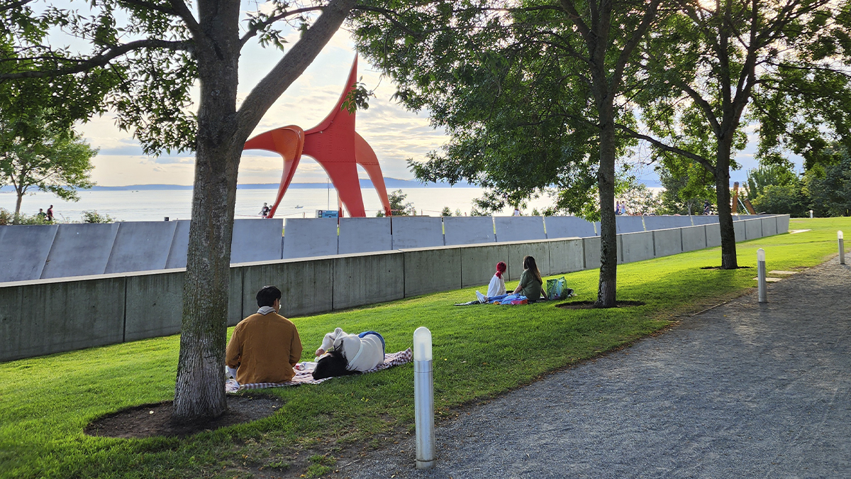
The sculptures themselves range from monumental to whimsical. Alexander Calder’s bright red “Eagle” stands forty feet tall against a backdrop of Puget Sound, its steel curves echoing the tankers and ferries that glide past. Richard Serra’s massive weathering steel piece, “Wake,” occupies a field of its own, its five pairs of locked toruses creating narrow corridors that shift the viewer’s sense of space and gravity. Near the water, a glass and steel greenhouse by Teresita Fernández catches light at different angles throughout the day, turning transparent, reflective, and opaque depending on where you stand and when.
What makes the Olympic Sculpture Park exceptional isn’t just the art or the views — it’s the way the design stitches the city back to the shore. The path bridges over both a major road and active railroad tracks, yet it feels effortless, like walking downhill through a garden. On any given afternoon, you’ll find joggers, families with strollers, tourists studying map apps, and locals who clearly come here every day, sitting on benches with coffee and a book, watching the ferries cross to Bainbridge Island.
The park is free and open every day from sunrise to sunset. That matters. In a city where the cost of living has skyrocketed, a world-class public space with no admission fee and no velvet ropes is not just a luxury — it’s a democratic act.
Myrtle Edwards and Centennial Parks: The Quiet Corridor
Continuing north from the Sculpture Park, the shoreline trail flows seamlessly into Myrtle Edwards Park and its neighbor, Centennial Park. Together, these two parks form a 1.5-mile waterfront pathway that feels distinctly different from the manicured ambition of the Sculpture Park or the bustle of the central piers.
Myrtle Edwards is the park where Seattle goes to exhale. The paved trail hugs the rocky shore, separated from the railroad tracks by a thin strip of native plantings. On one side, the waters of Elliott Bay stretch toward the Olympic Mountains, their snow-capped ridgeline visible on clear days like a postcard you never quite believe is real. On the other side, grain terminals and industrial cranes remind you that this is still a working port — a coexistence that gives the park its particular character.
Cyclists, runners, and walkers share the path with an easy informality. There are no vendors, no carnival games, no tourist traps. The benches face west. The sunsets here, when the sky cooperates, are absurd in their beauty — the kind of slow-burning orange and pink display that makes strangers on adjacent benches nod at each other in silent acknowledgment.
Centennial Park, which occupies the northern stretch, was created in 1975 to honor the city’s centennial and features a small fishing pier popular with crabbers and bottom fishermen. It’s not glamorous. The pier planks are weathered, the tackle boxes are battered, and the conversations tend to revolve around whether the Dungeness are running yet. But that unpretentious quality is precisely the point. Not every park needs to be a destination. Some parks just need to be a place where you can stand at the edge of the continent and feel the wind.
Waterfront Park and Pier 62: The New Heart of the Shoreline
The central stretch of Seattle’s revitalized waterfront is where the most dramatic changes have unfolded. Pier 62, rebuilt and reopened in 2020, has become the symbolic heart of the new waterfront — a broad, open public pier that juts into Elliott Bay with no building on it, just open deck, a few strategically placed shade structures, and an unobstructed panorama of the bay, the ferries, and the mountains.
The design philosophy here was restraint. Earlier iterations of the pier had included proposals for restaurants, retail, and even a Ferris wheel (the Seattle Great Wheel, in fact, occupies neighboring Pier 57). Instead, the city chose to leave Pier 62 largely empty — a public stage without a permanent show. The result is a space that adapts. Summer concerts, outdoor yoga classes, cultural festivals, and food markets rotate through the calendar. On quiet mornings, the pier belongs to early risers watching harbor seals surface between the pilings.
Adjacent to Pier 62, the emerging Waterfront Park stretches along the new surface-level boulevard that replaced the viaduct. The park incorporates wide promenades, rain gardens, play areas for children, and overlook points designed to frame specific views — the ferry terminal, the container cranes of Harbor Island, the distant volcanic cone of Mount Rainier on exceptional days. Mature trees and native plantings soften what could easily have become another sterile civic plaza.
The design team, led by James Corner Field Operations — the same firm behind New York’s celebrated High Line — understood something essential about public waterfront space: it has to work at multiple speeds. A tourist stopping for five minutes to take a photo needs a different experience than a downtown office worker eating lunch on a bench, who in turn needs something different from a family spending an entire Saturday afternoon. The layered design of the new Waterfront Park tries to accommodate all of them without feeling like it’s trying too hard.
Jack Block Park: The View From the Working Side
Cross the bay to the western shore of Harbor Island and you’ll find Jack Block Park, a small but powerful green space that offers something none of the downtown waterfront parks can match: a full-frontal view of the Seattle skyline reflected in Elliott Bay.
Named after a longtime Port of Seattle commissioner, the 8.5-acre park sits at the northern tip of West Seattle’s industrial zone, surrounded by container terminals and ship repair yards. Getting there requires navigating a stretch of road that passes truck depots and maritime supply warehouses — not exactly a pastoral approach. But the park itself is a revelation.
A wooden boardwalk leads through restored native plantings and wetlands to a broad viewing platform at the water’s edge. From here, the skyline rises across the bay in its full, slightly jagged glory — the Space Needle, the Columbia Center, the cranes, the ferries, all of it framed by water and sky. At night, the city lights reflect off the surface of the sound, and the experience borders on cinematic.
Jack Block Park also serves an important ecological function. The shoreline restoration project that accompanied the park’s development included the creation of intertidal habitat for juvenile salmon, part of a larger effort to mitigate the environmental damage caused by decades of industrial waterfront development. Interpretive signs along the boardwalk explain the salmon lifecycle and the challenges facing Puget Sound’s marine ecosystems — a reminder that these parks exist not just for human enjoyment but as part of a broader effort to repair the relationship between the city and the natural systems it depends on.
Alki Beach Park: Where Elliott Bay Becomes a Beach Town
Follow the shoreline southwest from Jack Block and the character of the coast changes dramatically. Alki Beach Park, stretching along the northern shore of the Alki Point peninsula, is Seattle’s closest approximation to a Southern California beach scene — if Southern California came with overcast skies, 55-degree water, and the persistent smell of cedar.
The 135-acre park features a 2.5-mile paved path along a sandy beach that faces directly across Elliott Bay toward downtown. On warm summer weekends, the scene is electric: volleyball games, bonfires in the designated fire pits, paddleboarders wobbling on the calm water, and a steady stream of cyclists and rollerbladers cruising the promenade. A small replica of the Statue of Liberty — a tribute to the Alki Point settlers who arrived here in 1851 — stands near the beach, looking slightly bewildered by the chaos.
But Alki isn’t just a fair-weather destination. In winter, when the crowds thin and the rain rolls in sideways off the sound, the beach takes on a brooding, moody quality that longtime Seattleites find almost more appealing than the summer bustle. Walking the shoreline trail with the wind in your face, watching the gray water churn against the seawall while the downtown towers disappear into low clouds — this is the version of Alki that earns its place in the hearts of locals.
The park also holds deep historical significance. It was near this shoreline that the Denny Party landed in November 1851, the group of settlers whose arrival is considered the founding moment of modern Seattle. A stone marker near the beach commemorates the event, though the park’s daily life has long since overtaken its historical gravity. History here is something you walk over on your way to get fish and chips.
The Ecological Thread: Restoration as Park-Making
One theme runs through nearly all of Elliott Bay’s waterfront parks: ecological restoration. Seattle’s shoreline has been heavily modified over the past 150 years — filled, bulkheaded, dredged, and paved to serve industrial needs. The parks that now line the bay are, in many cases, active sites of environmental repair.
At the Olympic Sculpture Park, the creation of a new pocket beach and the planting of native vegetation along the shore have provided habitat for forage fish and shorebirds that had been absent from that stretch of coast for decades. At Jack Block Park, the intertidal restoration project supports juvenile Chinook salmon, a species listed as threatened under the Endangered Species Act. Even Myrtle Edwards Park, with its seemingly simple strip of native grasses along the seawall, plays a role in filtering stormwater runoff before it enters the sound.
This ecological dimension adds a layer of meaning to what might otherwise be straightforward recreation spaces. When you walk through these parks, you’re not just enjoying a view — you’re moving through a landscape that is actively trying to heal itself, with human help. The interpretive signs, the native plant labels, the salmon viewing windows — they all serve as gentle reminders that public space and environmental stewardship are not competing priorities. They’re the same project.
A Waterfront Still in Progress
It would be dishonest to suggest that Seattle’s waterfront transformation is complete or without controversy. The Waterfront Seattle project has faced criticism over its cost, its timeline, and the extent to which it serves existing residents versus catering to tourists and new development. Affordable housing advocates have pointed out that the billions spent on waterfront beautification could address more pressing needs. Some longtime waterfront businesses — the souvenir shops, the fish bars, the slightly tacky but deeply loved tourist piers — have been displaced or diminished by the redevelopment.
These tensions are real, and they reflect a broader debate happening in cities worldwide about who public space is for and who gets to define its character. Seattle’s waterfront parks are not immune to the forces of gentrification, displacement, and uneven investment. The challenge going forward is to ensure that these spaces remain genuinely public — accessible, welcoming, and responsive to the full range of people who live in and visit the city.
But standing on Pier 62 on a clear evening, with the Olympic Mountains turning purple in the distance and the ferry horns sounding their low, resonant notes across the water, it’s hard not to feel that something important has been accomplished. Seattle spent the better part of a century turning its back on Elliott Bay. Now, park by park, path by path, the city is turning around again — and what it sees is extraordinary.
Getting There and Getting the Most Out of It
For those planning a visit, the waterfront parks are best experienced as a connected journey rather than isolated stops. The trail from the Olympic Sculpture Park south through Myrtle Edwards, then down through the central waterfront to Pioneer Square, covers roughly four miles and can be walked comfortably in a half day with stops for coffee, food, and contemplation. A separate trip to Jack Block Park and Alki Beach by water taxi from Pier 50 adds a maritime dimension to the experience and offers the unforgettable sight of the skyline growing larger — or smaller — across the bay.
Early mornings and late afternoons offer the best light and the thinnest crowds. Sunsets from Myrtle Edwards Park are legendary among locals for good reason. And if the weather turns — because this is Seattle, and it will — the rain only deepens the atmosphere. These are parks built for all seasons, all moods, and all the contradictions of a city that has never quite decided whether it belongs to the mountains, the forest, or the sea.
The answer, of course, is all three. And nowhere is that more evident than along the shores of Elliott Bay.